Godfrey Map Street Search
This search facility can help you to discover which map or maps in the Alan Godfrey reproductions of old Ordnance Survey maps in Greater Manchester includes a street in which you have an interest. The index contains 30,859 street and building names which appear on 112 individual maps. The maps concerned cover Central Manchester circa 1848 at a scale of 36 inches to the mile, Central Manchester and the surrounding suburbs and townships at various dates 1889 to 1932 at a scale of 15 inches to the mile and 15 inch to the mile maps for several other areas including Bolton, Oldham, Salford, Trafford and Tameside.

The Index
Please note that the addition of the location references is a work in progress and not all maps are yet fully indexed.
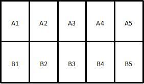
The maps do not come with an index to enable the precise localisation of streets and buildings. Manchester & Lancashire FHS has created an index to a large number of the maps covering Greater Manchester (the maps indexed can be seen by clicking the 'List of Maps Included in the Index' button above). The index allows a specific street or establishment (such as a public house) to be located to a specific map and to a small area within that map. Since there is no grid on these maps, his index has been based on the standard way in which the map sheets are folded. This divides each map into 10 smaller areas which have been identified as A1-A5 and B1-B5. When unfolded, the map appears as below:

Each street or establishment is indexed against the map(s) on which it appears and to the area of the map in which it is located. A street may appear on two or more maps and so may be indexed under each map on which it appears.
To use the index, simply search for the street required and then note the name of the map on which it appears and the location reference as described above.