Index to the Godfrey Maps
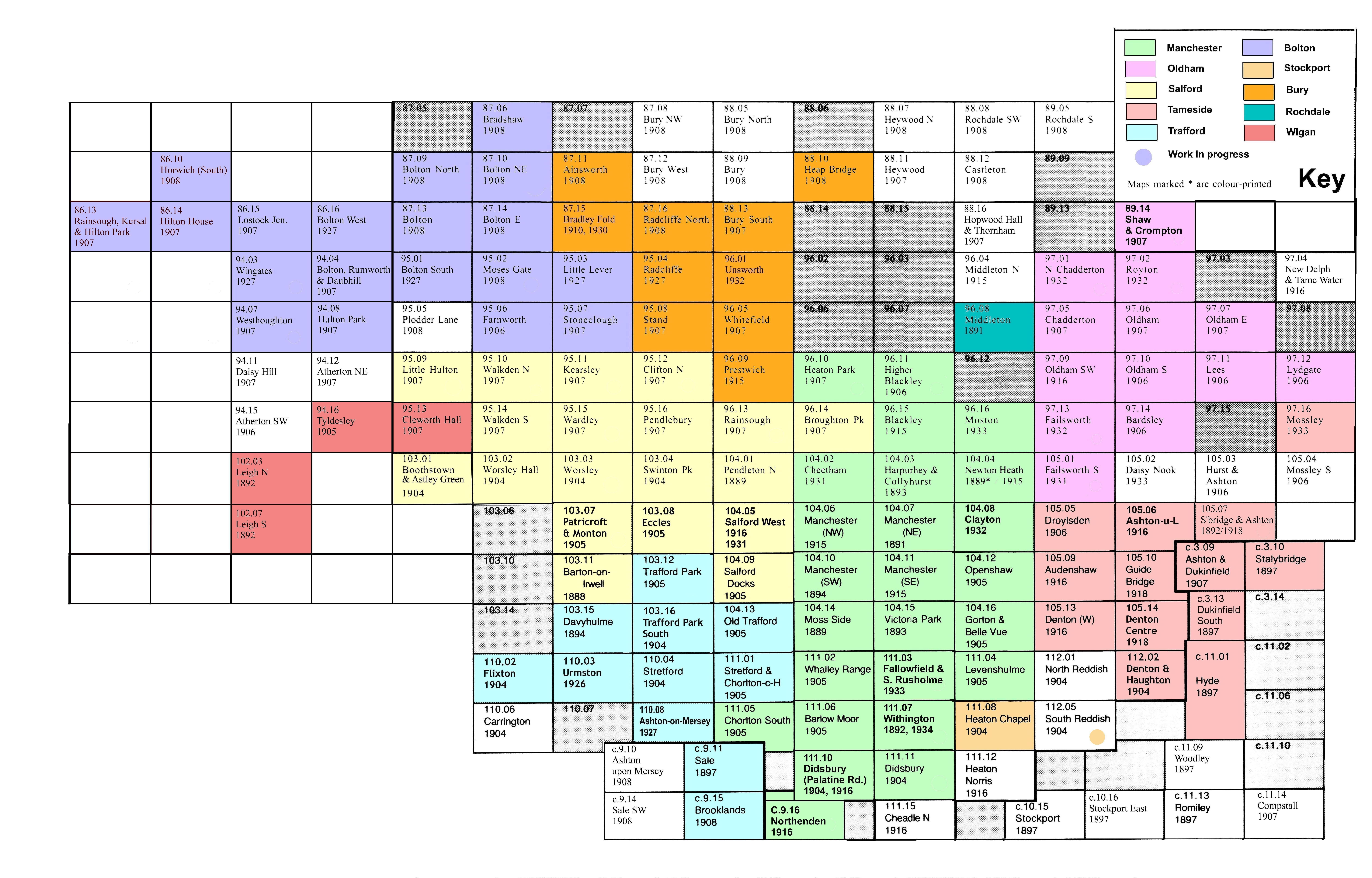
The maps included in the index are listed below. They are organised by the metropolitan borough to which they relate. This is, however, an approximation and for areas straddling borough borders, you should check under both boroughs. See the map below to determine which maps are included for each borough.
Maps which are available from the MLFHS Online Shop are linked to the shop page for the map where you will find some information about the extent of the map's coverage and from where you can purchase a copy.
Bolton 1908
Bolton (North) 1906
Bolton South 1927
Bradshaw 1908
Farnworth 1908
Hilton House 1907
Hulton Park 1907
Lostock Junction 1907
Moses Gate 1908
Rumworth & Gaubhill 1907
Stoneclough 1907
Ainsworth 1908
Bradley Fold 1910, 1930 (Two-sided map with 1910 on one side and 1930 on the other).
Heap Bridge 1908, 1930 (Two-sided map with 1908 on one side and 1930 on the other).
Radcliffe 1927
Radcliffe North 1908
Barlow Moor & West Didsbury 1905
Blackley & Lower Crumpsall 1915
Cheetham & Higher Broughton 1931
Chorlton-cum-Hardy & Stretford 1905
Didsbury and Heaton Mersey 1904
Didsbury (Palatine Road) 1904, 1916
Fallowfield & South Rusholme 1933
Manchester (NW) & Central Salford 1915
Northenden 1916
Whalley Range 1916
Withington 1892
Withington (Ladybarn & Burnage) 1934
Middleton 1891
Broughton Park & Crumpsall 1907
Boothstown & Astley Green 1904
Clifton North & Wet Earth Colliery 1907
Kearsley 1907
Manchester (NW) & Central Salford 1915
Patricroft & Monton 1906
Pendlebury 1907
Rainsough, Kersal & Hilton Park 1907
Salford West 1931
Swinton Park 1907
Heaton Chapel 1934
Dukinfield South 1897
Hyde 1897 (Note this is a two-sided map indexed C1-C5 and D1-D5 on the reverse)
South Denton & Haughton Green 1904
Godfrey Maps 15" to one mile
The colour coded areas show which maps are included within each of the Metropolitan Boroughs above.
